So there I was, loping along Forest Road 222, near the split with FR 519, having made the loop around Wing Mountain and heading back the last 1.5 miles downhill to the parking area near Highway 180.
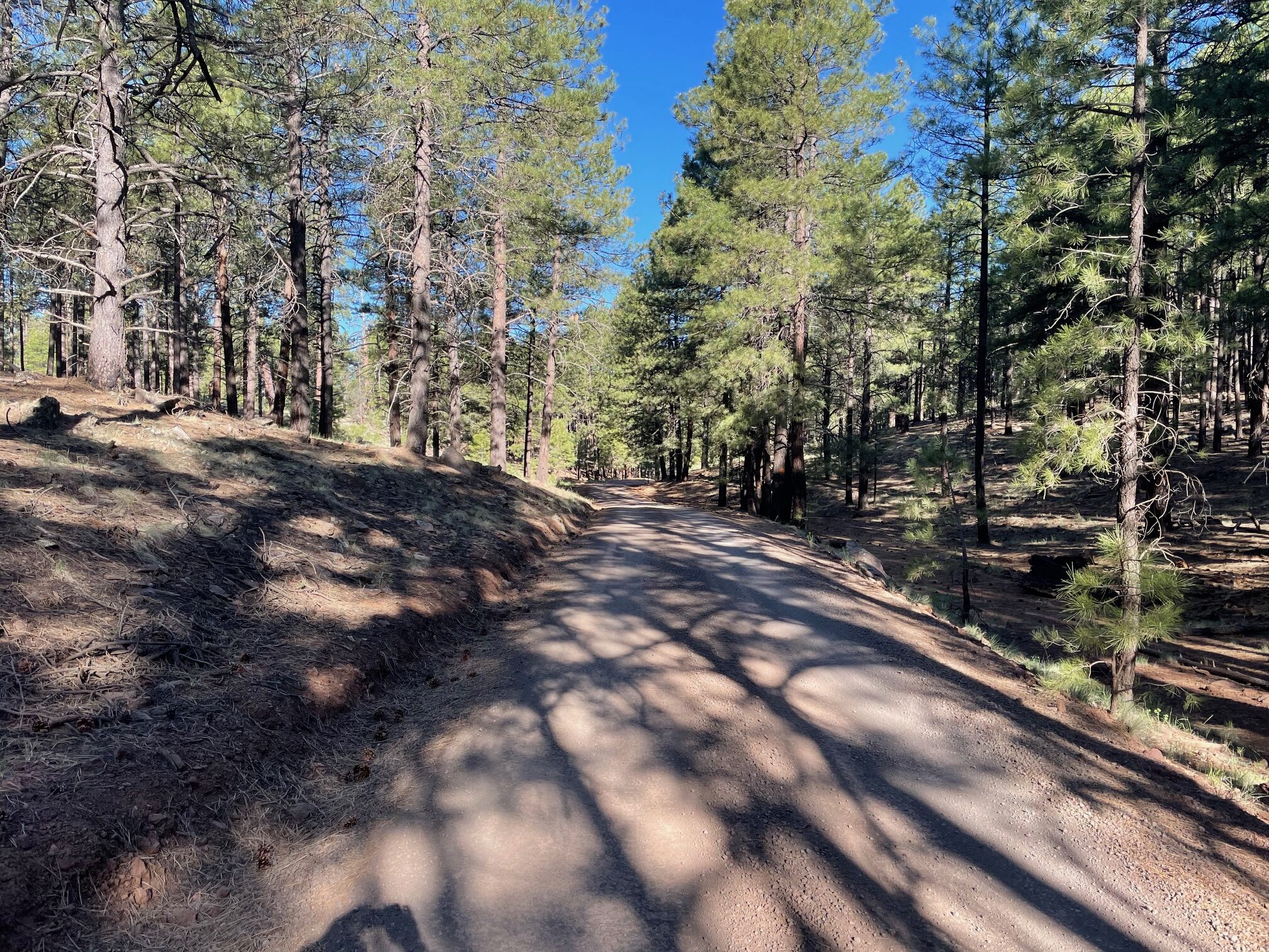
When the area is not snowed in, I run Wing Mountain at least twice a month, maybe more often. It’s 10.2 miles, a perfect medium-to-long run on mostly smooth forest roads shaded by pines and dotted with ponds. There’s climbing, to be sure, but more of a rollercoaster ride, nothing too steep.
You, the avid Flagstaffian runner, may know Wing Mountain as the loop part of the longer 19.9-mile A-1 Mountain run that is popular with the pros. It’s become so popular, in fact, that so-called running tourists in town for a little high elevation training seek out A-1, which starts just off the Interstate 40 exit west of Flagstaff and goes south and west for eight miles until the Wing Mountain loop.
Sometimes, you know, I don’t want to run almost 20 miles. Sometimes, I want to halve that, which is where the Wing Mountain (FR 222) option comes in.
Granted, the pros know about this one, too. I’ve seen the Dark Sky Distance contingent in the parking lot off of Highway 180 more than a few times. But it’s not as crowded, say, on a Sunday morning, as A-1.
Crowded with runners, that is. Wing Mountain is a popular dry camping spot, and the occasional four-by-four blows past you, mushroom clouds of dust left in their wake. The same is true for A-1, as a whole, though. People camp there and blow by you in their pickup trucks with impunity.
Occasionally, when doing my shorter Wing Mountain loop, I’ll get passed by elites presumably doing the longer A-1 route, which leads me back to the opening anecdote.
On this day, I was just about to make the left turn away from the loop for the final 1.5 miles back to the car, when I heard footsteps behind me. Footsteps coming fast. I was still ahead of this pursuer after making the turn, but he breezed by me shortly thereafter. I watched him faded into the distance; he had great turnover and arm swing, impressive.
A few minutes later, I saw the same figure heading back my way, moving just a little slower.
I was just about ready to give my hearty wave and nod when, suddenly, the runner stopped.
“Is this still A-1?” he asked, breathless.
I set him straight, told him that he made a wrong turn before completing the full loop from the A1 side. I told him to retrace his steps, make a left at the next intersection.
“You know you’re going the right way when you pass a shooting range on your right,” I said, sending him on his way.
What I didn’t tell this elite (or college runner; hard to tell, because everybody seems young to me) was that shortly after passing the shooting range, he’d face the biggest climb of the run for about 1.5 miles before getting to the intersection that heads back to the A-1 parking lot.
Really, it’s not that big of a climb, but coming in a 19.9-mile run, you feel it.
Of course, the guy I ran into was going to be running longer than that, given the detour he made on the 1.5-mile offshoot. I noticed he did not carry any fluids. I silently wished him well.
If you’re lazy like me and only run the 10.2 loop, you don’t really need water or carbs – except maybe if it’s really hot out.
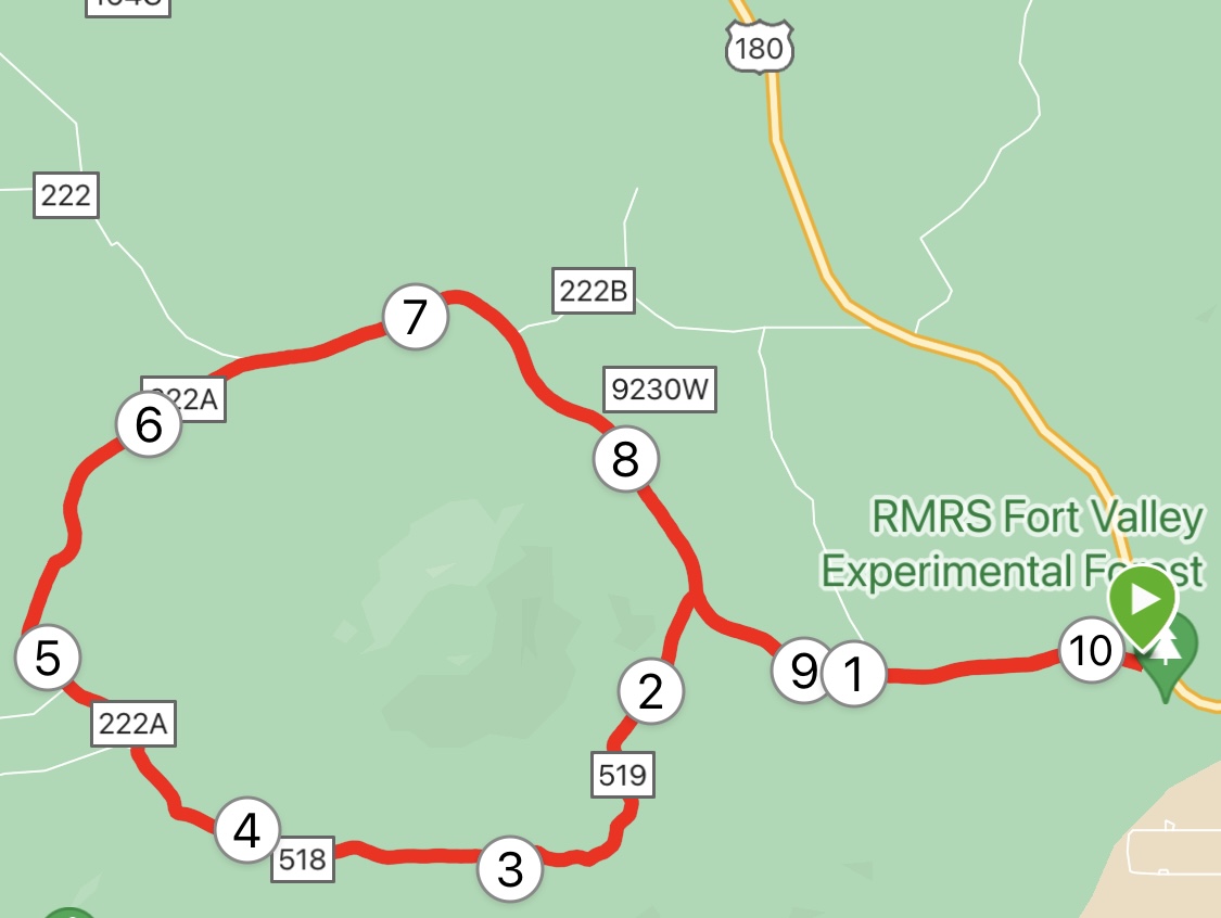
I also would recommend running the loop clockwise; that way, you get the climbing out of the way early and can cruise with only little rollercoasters the rest of the way. No matter which way you go, the first 1.5 miles is uphill. You gain about 200 feet by the time you make the left turn, but it’s a gradual climb.
Not-so-gradual is the climb after the shooting range. From 1.5 miles to the 2.7-mile point, you gain an additional 220 feet. From that point, though, it’s pretty much equal uphill and downhill running.
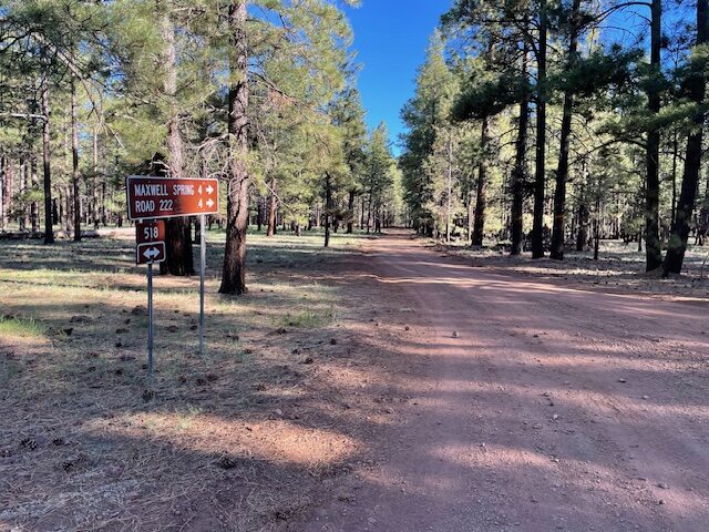
Just make sure at the intersection about 3.2 miles into the run that you veer right to stay on the loop (with Wing Mountain looming on your right) and a sign saying “Maxwell Spring 4” pointing the correct way. If you go left, you’re heading back on the A-1 Mountain route and will add much unintended mileage to the trek.
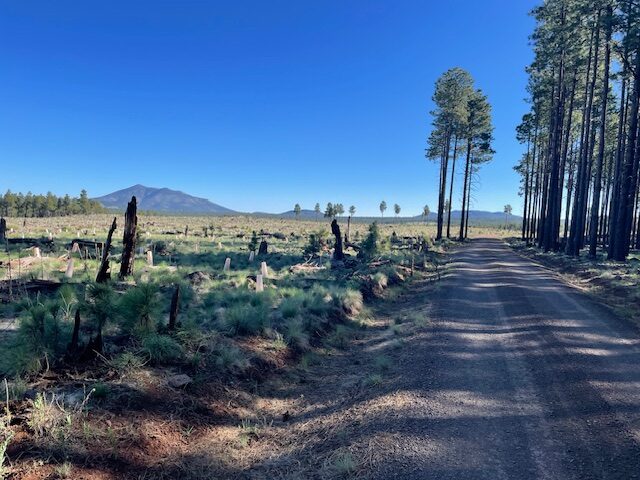
As stated, much of the Wing Mountain loop itself is shaded, but once you climb out of a small canyon at about six miles in, on the eastern side, you’ll be greeted with a valley dotted with burnt remains of trees from a fire decade old. It’s a stark reminded of the damage wrought by wildfires.
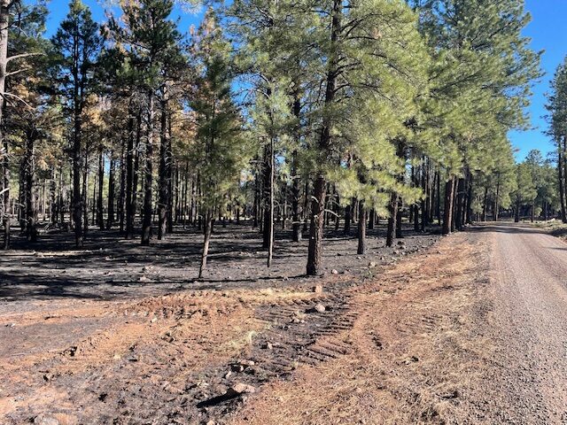
Farther on, near Maxwell Spring, you could see (and smell) the residue from the controlled burns that forest officials set in the area in late May to help prevent larger, more devastating fires. The forest floor was scorched black and wisps of smoke still hovered.
Soon enough, you are back on level and smooth forest roads on the north side of Wing Mountain, past the abandoned snow park slopes and back to the downhill turn for home.
Wing Mountain
Distance: 10.2 miles.
Driving Directions: From Flagstaff, take Highway 180 (Fort Valley Road) beyond the Snowbowl Road turnoff and head farther west to the FR 222 sign. Turn left and park at the pullout before the gate.
Route: Run south toward the mountain for 1.5 miles, then, at the junction, turn either left or right and follow the loop around the mountain.
Elevation Gain: 741 feet
Highest Elevation: 7,789 feet
Leave a Reply