Sartre’s famous dictum, “Hell is other people,” has never been more applicable than when it comes to traversing many of the higher-elevation Flagstaff trails in October, prime aspen-gawking season.
I try to be all Zen and deal with it, but I get a little annoyed sometimes at the traffic and the congestion on the single track. (Don’t even try to go to Aspen Corner, up by the Snowbowl, these days.)
But here’s an alternative that is somewhat out-of-the-way but still will have you quaking with excitement at the quaking, gold-coin aspens that stitch our autumn trails: The Abineau-Bear Jaw Trail Loop, which also includes a stretch on the upper reaches of Waterline Road.
What, you were expecting some secret, out-of-the-way trail known only to locals and considered too much effort by those weekend tourists up from the Valley?
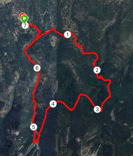
No, most people are aware of Abineau-Bear Jaw Trail Loop (with Waterline Road serving as the connector), a 7-mile trek that circles the north side of the San Francisco peaks, just a scant two or three miles above the vaunted aspen section of the Inner Basin Trail.
It’s featured on all the maps. The Coconino National Forest ranger station puts its flier front and center. No less an arbiter of outdoors culture than Arizona Highways magazine proclaims that a certain stretch of trail on the Bear Jaw boasts “the most beautiful aspen grove on Earth.”
So why in the fall (not to mention late spring and all summer) is the Abineau-Bear Jaw so little used compared to the Inner Basin?
Just a theory, but it could be because the loop is steep, rocky and unforgiving. Simply put, it’s freakin’ hard — and too much effort for most.
But hardy Flagstaffians, they know the charms of the Abineau-Bear Jaw outweigh the difficulties. They aren’t afraid of the black-diamond icon (denoting “strenuous”) on all the maps and they aren’t quaking at the prospect of downed trees to scale and other avalanche debris.
Imagine how superior you will feel to those motorists settling on Aspen Corner or Kachina or those willing to take the three-mile hike up FR 552 to Lockett Meadow.
Though the trailhead parking at Abineau-Bear Jaw is not as expansive as other locales, I’ve never seen the lot full — even on a picture-perfect early October weekend.
It actually takes less time to get to the Abineau-Bear Jaw trailhead than to Lockett Meadow, especially if you take the Highway 180 route west of town, and the dirt roads heading in (Forest Road 418 and 9123J) aren’t too bad if your car even has a little high-clearance.
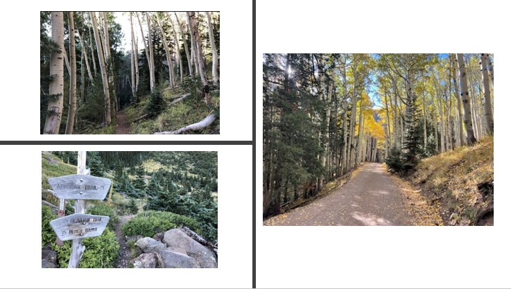
Once on the trail, you ramble slightly about a half-mile through a lush meadow partially shaded by ponderosa pines and scattered aspens, giving you a taste of what’s to come. When you get to the junction at the border of the Kachina Peaks Wilderness, you have the option of turning left (clockwise) onto the Bear Jaw Trail or right (counterclockwise) onto the Abineau.
My first time making this choice a few years ago, I thumbed through sign-in notebook to see which way users before me had gone. Most chose the Abineau first, so, being a natural contrarian, I picked Bear Jaw. Since then, it’s become a habit—Bear Jaw first.
Actually, that first time, I peered up both trails from the split and saw that Bear Jaw’s path was smoother (Abineau, from that vantage point, looked boulder-and-branch strewn.) Plus, most of the really pretty aspen groves are on the Bear Jaw, the first 2.7 miles of the run.
Unlike the Inner Basin aspen groves, which follows along gentle switchbacks with roots but no major footing woes, the Bear Jaw segment is an obstacle course of boulders and jagged rocks that resembles, well, a bear’s jaw.
It’s good, in a way, that the technical aspect of the trail forces people to go slower — better to appreciate the white-trunked, multi-hued leafed aspens swaying in the light breeze.
You’ve mostly left the aspen groves behind by the time the Bear Jaw Trail ends, at 9,700 foot elevation. The final uphill push is the stuff of hands-on-knees scrambling over boulders.
It’s a nice break when you arrive at Waterline Road, the smooth (by comparison) forest road you traverse for two miles to get to the head of the Abineau Trail. The directional sign there states it is 2.8 miles to the Inner Basin Trail, where the “famous aspens” await, but, really, you don’t need to make the detour. Bear Jaw’s aspens are good enough.
The major downside for taking Bear Jaw first is that the entire two miles on Water Line Road are uphill. But it’s tree-lined and for all but the late afternoon, mostly shaded. The miles go quickly, and the sights as you near the Abineau Trail bespeak expansive alpine views in every direction.
Look north and you see the yawning gap in the plateau that is the Grand Canyon. Crane your neck upward and to the south and Humphreys Peak looms. Gaze down and, well, you see with awe and trepidation the steep rocky, fallen-tree path you must descend to complete the loop.
But it’s downhill, right? Easy.
Uh, no.
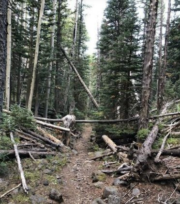
The canyon involves much rock hopping and there seems more downed trees than vertical ones, especially during the early stages of the downhill. That’s because of a significant avalanche that, essentially, scraped the canyon clean in 2005. Though much time has passed, the scars are still evident. Here’s how the Arizona Daily Sun described the carnage at the time: “Spruces more than 50 feet tall were tossed around like toothpicks in a river, some of the biggest limbed from top to bottom in a matter of minutes.”
It got so technical on the descent that, embarrassing to note, it took me nearly 19 miles to traverse a mile.
From a Force-of-Mother-Nature perspective, the Abineau Trail is impressive. But it’s the aspens along the Bear Jaw — and the avoidance of trail tourists — that make Arizona Highways wonder, “It might be the perfect trail.”
Abineau-Bar Jaw Loop Trail
Distance: 7 miles.
Driving Directions: Drive northwest of Flagstaff on US 180 for 19.5 miles and turn right on FR 151 (Hart Prairie Rd.). Drive 1.5 mile and turn left on FR 418. Drive 3 miles to FR 9123J. Turn right (south) on FR 9123J and drive 1.2 miles to the trailhead.
The Route: From the trailhead, go about a half mile to the junction where the trail splits. To the left in Bear Jaw; to the right, Abineau. Bear Jaw runs 2.7 miles to the junction with Water Line Road. Turn right and go on Waterline for 2.3 miles to the Abineau junction. Turn right and go downhill 2 miles and follow the trail back to the trailhead.
Elevation Gain: 1,847 feet
Highest Elevation: 10,316 feet
Leave a Reply