Heraclitus, that ancient philosopher who touted the universal flux theory, once said that you can’t step in the same river twice. And that is meant to be a good thing, the impermanence of life, the rejuvenation that comes with flow and all that.
But, unlike the great thinkers, a mediocre mind like mine craves stability, familiarity, the security in knowing that the trail I ran last year or last week will be the same when I return next week or next year.
Which brings me to the matter of the Schultz Creek Trail, the first of Flagstaff’s iconic trails I ventured onto when I moved her in 2019.
Last week, I returned to the lush trail that begins at the “Y” on the corner of Schultz Creek Road and Elden Lookout Road. I knew what to expect; I knew it had been changed. Rebuilt, yes. Improved, yes, for flood mitigation and erosion control. More parking at the trailhead, an easier entry to the creek section itself. Kudus to the forest service folks and scores of Flag volunteers who made this happen.
But — and you knew there was a “but” coming, didn’t you? — part of me misses the old start to the Schultz Creek Trail, which meanders uphill for 4.7 miles to the Sunset Trailhead.
I liked how, in the former configuration, you immediately plunged into the tree-shaded depths of the creek. I liked its initial flatness before the steady climb kicked in. I liked that the trailhead itself was tucked away after a steep downhill, hiding your car from the sketchy characters (just kidding!) in that part off town.
Now, of course, the trailhead has been moved down about a half mile to the “Y,” where all the hipster mountain bikers hang out. And the start of the trail, dare I say, is kind of boring. The first 0.2 of a mile is on a wide, well-manicured, crushed granite trail that wraps around before leading to the singletrack.
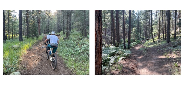
About the new singletrack section: The abrupt change in terrain and elevation surprises you, turning from Buffalo Park-style crushed granite to narrow, boulder-embedded uphill singletrack. It’s a shock to the system, but you get used to it. This part of the Schultz Creek is along a ridgeline, meaning that if you look west and down, you see the old creek trail waiting below, still evident but starting to be swallowed up by nature.
Once you cross the junction with the Chimney Trail, where most of the mountain bikers will veer off, you’re back in terra cognita. It felt good to trod on familiar turf; I didn’t even curse at the exposed roots that threatens to send me face-planting.
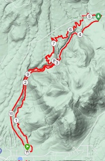
True trail climbers will scoff if it’s suggested that the Schultz Creek Trail, heading north, is a good uphill workout. Sure, it doesn’t have the killer Vert, as they say, but it’s a long, steady climb that builds strength and endurance. The entire 11-mile loop gains 1,060 feet, but the Schultz Creek Trail segment takes up 946 feet of that.
Does that make the rest of the run, well, easy?
Sort of.
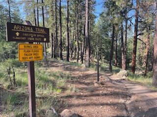
After crossing the Sunset Trailhead parking lot and finding the Secret Trail sign, the climbing and technical, rocky trail is mostly behind you. Enjoy. You only stay 0.3 of a mile on the Secret Trail before veering left onto the Arizona Trail (Segment 34a, for those consulting maps).
The next three miles on the winding, lush AZT brings some much-needed shade and views of riparian and arboristic diversity.

Remember, though, after about 2.5 miles on the AZT, to look for the sign for the AZT “Equestrian Bypass” that takes you back to the Schultz Creek Trail (or Schultz Pass Road). If you keep going straight on the AZT proper, you’re heading toward the Moto Trail and a longer run (not that there’s anything wrong with that).
Speaking of not making the run longer, once you reach the junction with Schultz Creek Road, you have a decision to make: Cross the road to stay on the singletrack that soon lead back to Schultz Creek, where you’ll retrace your steps back to the trailhead; or, cruise down Schultz Pass Road, dirt but soft and without rocks and roots.
I chose the easy way back.
Do not judge me.
Schultz Creek Trail-Secret Trail-AZT-Schultz Pass Road
Distance: 11 miles
Driving Directions: From downtown Flagstaff, take Highway 180 to Schultz Pass Road, and turn right. At the corner of Schultz Pass and Elden Lookout Road, park at the “Y.”
Elevation gain: 1,060 feet.
Highest elevation: 8,114 feet


Leave a Reply