Far be it from me to tell the Forest Service what to do and, to be frank, the advice I’m about to give certainly will be met with scorn by non-runners as well. Then again, would non-runners even be on this website to read this in the first place?
OK, here goes. My proposal, unasked for and probably unwise:
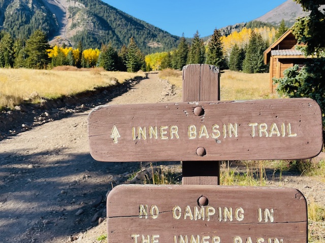
Keep the road up to the Lockett Meadow Campground – and the start of the Inner Basin Trail – closed for good. In other words, make this temporary closure of FR 552 due to the erosive effects of the 2022 Pipeline Fire and its concomitant flooding permanent.
You may scoff and ask, So this dirtbag is suggesting that what visitors must endure now, parking at the bottom of FR 552 and humping up three miles and 938 feet just to get to the trailhead? Is he crazy?
Yes and perhaps.
Hear me out.
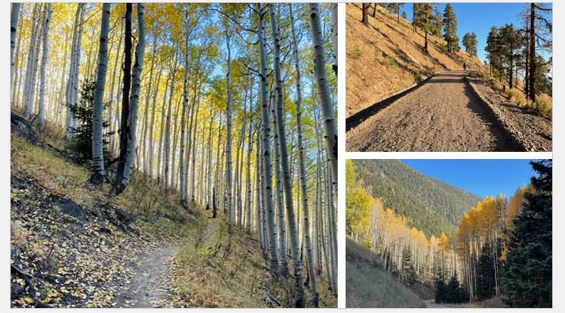
First, for runners, the three-mile, nearly 1,000-foot climb on 552 is a good warmup for the technical aspen-root saturated singletrack that must be navigated on the first 1.8 miles of the Inner Basin Trail and, should you continue, on the uber-rocky 2.2 miles to the trail’s terminus at the Weatherford Trail. FR 552 is smooth and, after the first half-mile isn’t really that steep – but steep enough to get the heart pounding.
Second, it’s such a pleasure to traverse a dirt forest road without the constant worry that rampaging pickup trucks and careening four-by-fours are going to buzz by and leave a mushroom cloud of dust for runners and mountain bikers to inhale.
Third, there’s a certain pride of accomplishment and camaraderie to be had as you join the fall leaf-peeping crowd on the pilgrimage to gawk at the quaking aspens, now in full blazing gold on the mountain. Early last Sunday morning, I saw two other runners making the same climb and at least a dozen (more on the way back) hikers, a half-dozen bikers and two horses. Human-powered people took over the width of the trail, with nary a worry about having to step aside for automobiles.
And fourth, the campground itself still had plenty of overnighters, but the place wasn’t overrun by people and cars as it usually is throughout October.
Now for the counterargument: Yes, I realize permanently closing 552’s access for automobiles makes it impossible for people in wheelchairs and other mobility issues to drink in Lockett Meadow’s many colorful sights. But there are several alternative leaf-peeping locales in and around the San Francisco Peaks – most notably Aspen Corner, right off the paved Snowbowl Road, on the way to the ski resort, or the Kachina Trail at the Snowbowl lot itself.
Some may wonder why the Forst Service has even closed 552 in the first place. It’s been two years since the fire and flooding and, running up it on Sunday, it looked it fine shape. Better, in fact, than in past years when 100s of cars each weekend wear down the road.
The answer is posted at a makeshift kiosk right by the closed gate. It reads, in part: “Since 2022, road work has been completed to make the road passable for administrative access for the City of Flagstaff to access critical Water Systems. This road might look fine today, but the road is NOT safe for public travel, as several road features, such as road stabilization structures, have been lost.”
The missive ends by stating that they hope to have the road back open to auto travel by fall of 2025.
To which I say, no rush.
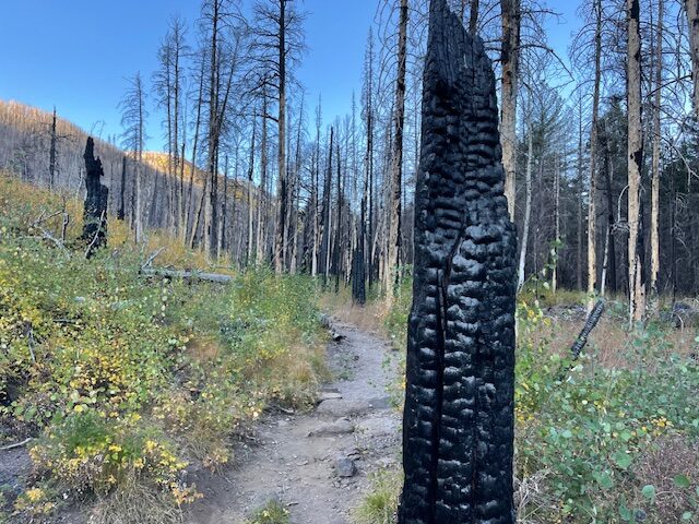
I’ve run on Inner Basin twice since the reopening of the trail, and while there remains many an aspen at which to gawk, there also is pretty of charred remains to mourn.
The first 1.8 miles of the Inner Basin – from Lockett Meadow to Waterline Road – has the most noticeable damage. The singletrack trail itself is not washed out, despite the flooding; it’s just as root strewn as ever, just begging for you to twist of ankle. But part of the tree-laden forest has been denuded and blackened stumps and downed trunks dominate the first part of the climb.
Eventually, about the time you hit the switchbacks, the intact aspens come into view, and you’ll pass many a hiker stopping and holding smart phones aloft for that perfect Instagram moment.
The 0.3 of a mile to traverse Waterline to get to the continuation of the Inner Basin – the upper climb – is a smooth forest road lined with green ponderosa pines and stands of golden aspen.
And the last 2.2 miles of the Inner Basin – the climb up to Weatherford — mostly as same as always, save a few fire remnants. It’s rocky going, in other words.
After you veer slightly left at several forest service sheds, the forest opens up into a lush meadow that might make you feel the urge to dress in lederhosen, blow an alphorn and yodel. There are still aspens about, not to mention plenty of pines, but you aren’t wending your way through them; they, instead, serve as a boundary as you ascend toward the peaks looming ahead. There’s about 1,500 feet of elevation gain in the final 2-mile climb to Weatherford, and parts of it can be a slog of loose boulders and jagged rock in exposed sun.
You know what’s really fun: the final three miles downhill on smooth FR 552 back to the start. By 9:30 on Sunday morning, I passed families with canteens and weighed down backpacks, couples with dogs, mountain bikers (including one with a rifle slung across her back) and a couple of equestrians trotting on up.
Not a car to be seen, or dodged.
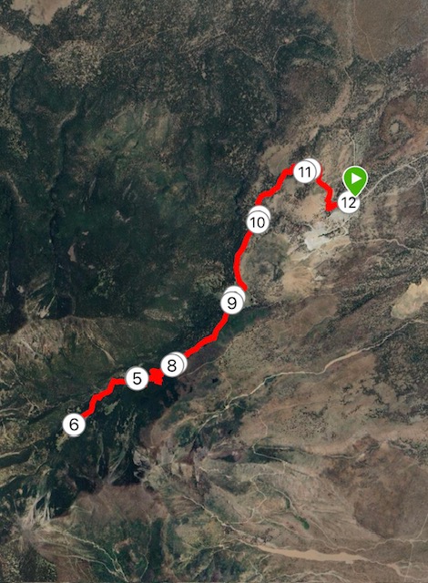
FR 552/INNER BASIN, 12.1 OR 16.1 MILES
Driving Directions: Drive northeast of Flagstaff on Highway 89 for 12.5 miles. Turn left on Forest Road 545, directly across from the Sunset Crater National Monument turnoff. Follow it 1.2 miles to FR 552 and the sign for Locket Meadow. Park on the pullouts next to the locked gate.
The Route: From the gate, go 3.2 miles up FR 552 (it flattens a bit in the third mile) to Locket Meadow and the Inner Basin Trailhead. Go 1.8 miles to the junction at Waterline Road. Go right on Waterline for about a half-mile, then veer left and look for “Inner Basin” signs. It’s another mile to reach the Inner Basin meadow and the City Water facility. Turn around here for a 12-mile run. For another four miles, continue straight up Inner Basin to the junction with the Weatherford Trail.
Elevation gain: 2,218 feet for 12 miles; 3,310 for 16 miles.
Highest elevation: 9,827 feet for 12 miles; 10,944 feet for 16 miles.
Leave a Reply