Lately, I’ve avoided going to Sedona to run. Nothing personal against the crystal-clutching, vortex-vibrant people of that lovely and rutilant locale. But, you know, the traffic and the tourists and the construction and the restrictive shuttle-service to many trailheads. Really, are they ever not doing construction on Highway 89-A?
I was, though, compelled to make the trip south recently, thanks to the folks at the Northern Arizona Trail Runners Association. It chose, as its Saturday morning run, what founders call the Yavapai Vista Figure Eight Loop, a run “…we haven’t done in years!” it said on its website.
I was intrigued, and I also was jonesing for a trail run while the Flagstaff trails remain snow-covered. Plus, it was the exclamation point that organizer Neil Weintraub added that sold me.
The great thing about this trail run is that you don’t have to drive through Uptown Sedona and its roundabouts to get to the trailhead. Oh, you can, if you want. But because the Yavapai Vista Trailhead is off on Highway 179, you have the option of driving on Interstate 17 to the Sedona exit and coming in the back way. It may be a few minutes longer, timewise, but less stress-inducing. Another bonus: You can park right at the trailhead.
Enough about logistics. What about the trail?
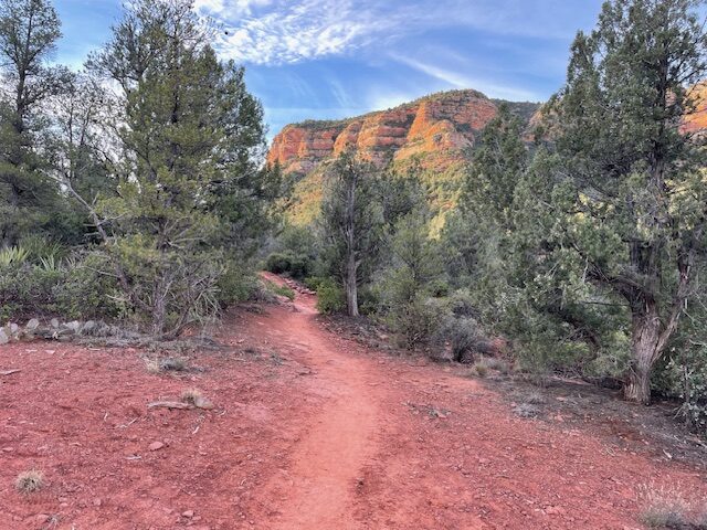
It’s a rocky, wavy and challenging five-miler, two separate loops. There’s not a great deal of climbing – 670 feet, according to my Coros watch – but its technicality makes it a bit tricky in spots. That, and the mountain bikers. A big part of the Figure Eight run along the Slim Shady Trail (a nod to Eminem, perhaps?), which is a popular mountain biking course. Pro tip: Do this trail in the morning hours, before the bikers wake up and take over.
You can traverse the figure eight, obviously, in either direction. But, taking direction from NATRA’s Sedona expert, David Blanchard, the Saturday morning group, 18 strong, started south on Slim Shady for a mile. This is a good way to ease into the rockiness to come. It’s slightly uphill from the get-go, but the well-trod bikers have smoothed out the path.
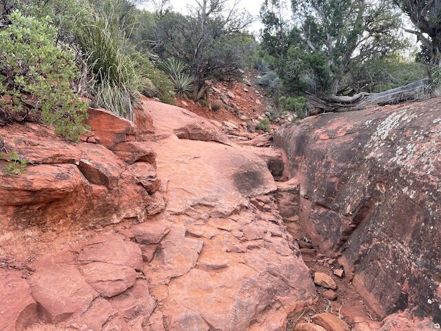
At 1 mile, with Bell Rock looming on the other side of Highway 179, you make a sharp right onto the Made in the Shade Trail. (Signage, by the way, is excellent on this and other Sedona trails.) The next 1.2 miles begins with a short but steep climb of about a half-mile, but it soon levels off and you can regain that steady, meditative, blissful Sedona breathing.
Just shy of the 2.5 mark, overall, you have finished the first loop and find yourself back on the 0.3-mile stretch of Slim Shady that you’ve already completed. You do not return to the trailhead lot, though. Rather, you then veer left as Slim Shady climbs north-west above the trailhead for another mile. This, to me, was the highlight of the run – up and down, rock-hopping alternating with smooth stretches.
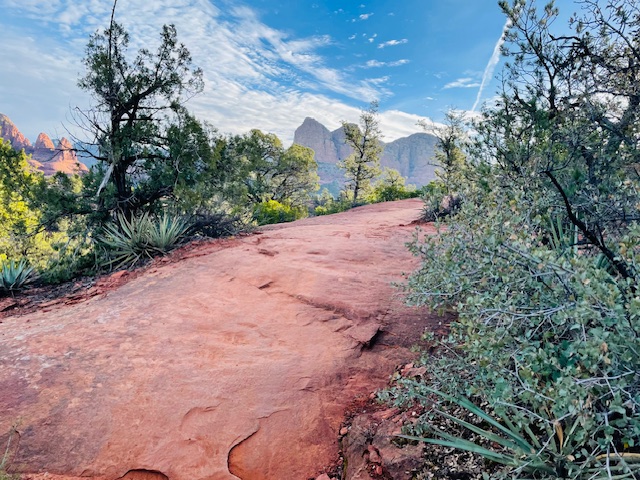
Quickly, back on Slim Shady, you’ll reach the junction with the Hiline Trail on your left. Of course, if you want a true hill workout that will test your climbing chops, you can add an out-and-back on Hiline. It’s 3.2 miles and 562 feet of elevation gain, rated as “difficult” by the must-have Emmitt Barks Cartography’s “Sedona Trail Map.” Have fun. I stayed on Slim Shady, thank you very much. On Slim Shady, you can really tell that this is a mountain-bike course, with high-banked curves worn smooth by nubbly bike tires.
Eventually, you come to a four-way junction that provides several options. If you want to complete the second loop and finish with five miles, make a sharp right for 0.4 of a mile on the Templeton Trail and finish up on the beautiful Hermit Trail. Though it parallels Highway 179, the Hermit Trail dips below the road and you barely can detect that cars are cruising by.
Afterward, many of the NATRA runners gathered at a café in Oak Creek Village – smart to avoid heading back via Sedona on a Saturday during tourist season.
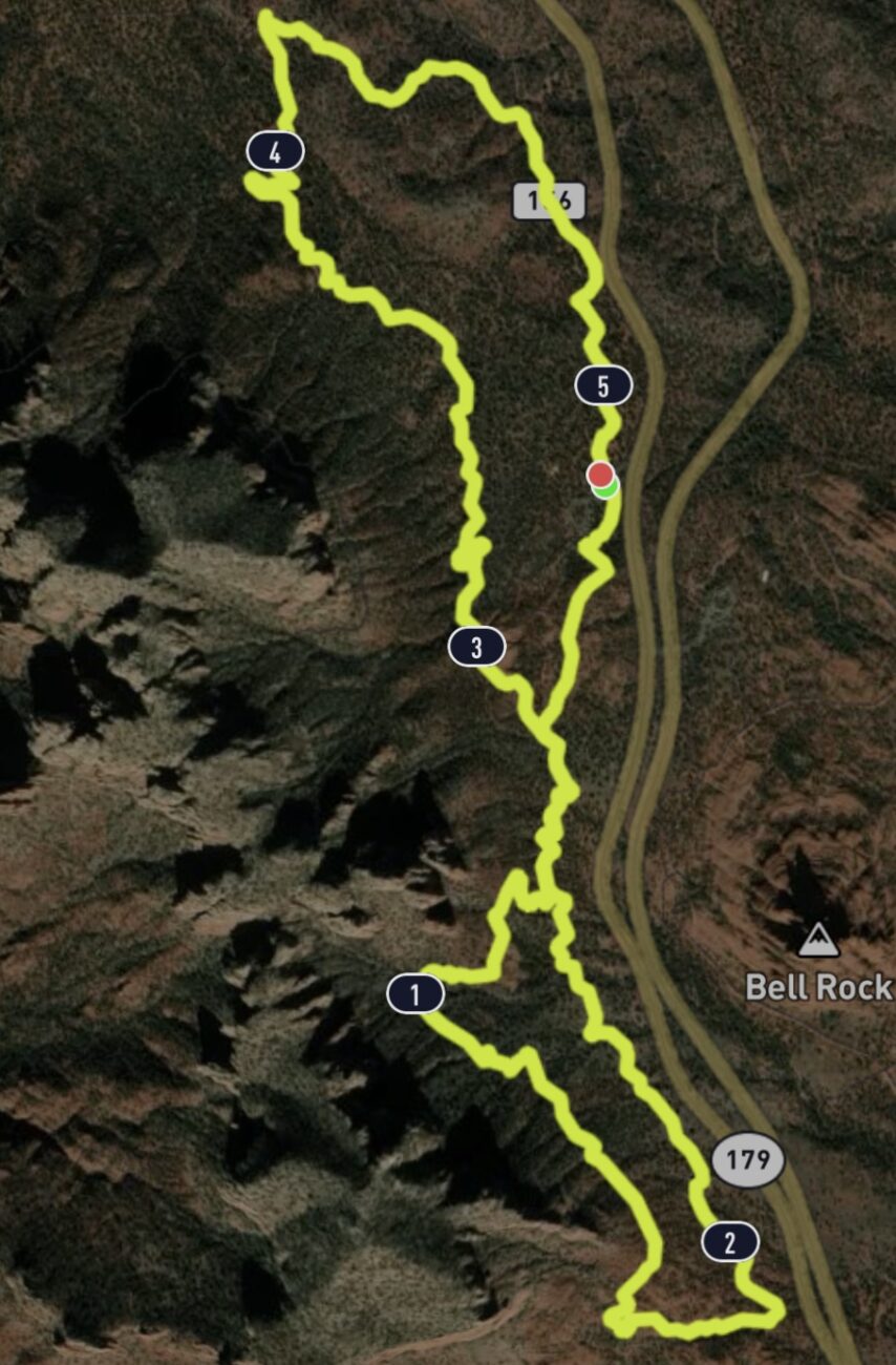
Yavapai Figure Eight, Sedona
Distance: 5 miles
Driving Directions: From Flagstaff, there are two ways to getting to the Yavapai Vista Trailhead. To avoid traffic through Uptown Sedona, take I-17 to the Sedona exit, head east on Highway 179 for about six miles, cross to the west side of the highway and turn into the Yavapai Vista exit. Through Sedona, take Highway 89-A 23 miles to Uptown Sedona. At the second roundabout, turn left (south-east) onto Highway 179. Turn right at the Yavapai Vista exit. Parking at the trailhead is $5.
Route: From the trailhead, start going south on the Slim Shady Trail. Turn right onto the Made in the Shade Trail, then return to the Slim Shady Trail. At a four-way intersection, make a sharp right (east) onto the Templeton Trail, then make a right onto the Hermit Trail and return to the trailhead.
Elevation gain: 670 feet
Leave a Reply